


GPS Satellite Earth Map View
Description of GPS Satellite Earth Map View
GPS Satellite Earth Map View is a navigation application available for the Android platform that provides users with satellite imagery and street views to assist with route planning and navigation. This app is designed to facilitate easy travel by offering users comprehensive mapping tools that include live traffic updates and detailed geographical information.
The app features a user-friendly interface that allows individuals to navigate using GPS satellite maps across various countries. With the GPS Satellite Earth Map View, users can easily find their current location and explore their surroundings. The application employs a combination of satellite maps and street view images to deliver accurate navigation guidance.
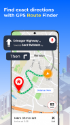
Users can take advantage of the turn-by-turn navigation feature, which provides step-by-step directions for reaching their desired destinations. The app is equipped with a voice navigation option that enhances the user experience, allowing for hands-free operation while driving. This feature is particularly useful for individuals who need to focus on the road and prefer auditory instructions over visual cues.
Traffic maps are integrated into the application, providing real-time updates on road conditions. This functionality helps users avoid congested areas and select the quickest routes to their destinations. By checking the traffic updates before departing, individuals can save time and make informed decisions about their travel plans.
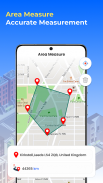
Another notable feature of GPS Satellite Earth Map View is its ability to display detailed 2D maps. These maps offer users a comprehensive view of their surroundings, including roads, landmarks, and points of interest. The accuracy of these maps allows for precise navigation, ensuring that users can find the best routes available.
The app also includes a live camera feature that allows users to see their current location in real-time. This can be particularly helpful when trying to locate specific places or when navigating through unfamiliar areas. The live camera function enhances the overall navigation experience by providing a visual representation of the user's environment.
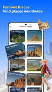
GPS Satellite Earth Map View supports various geographical features, enabling users to explore different terrains and landscapes. The application provides aerial views of cities, which can help users familiarize themselves with the area they are navigating. This feature is beneficial for travelers who want to gain a better understanding of their surroundings before arriving at their destinations.
In addition to providing navigation assistance, the app allows users to search for specific locations, such as restaurants, stores, or other points of interest. The search functionality is straightforward, enabling users to quickly find what they are looking for without unnecessary complications. This can be particularly advantageous for individuals who are in a new city or area and are unfamiliar with local amenities.
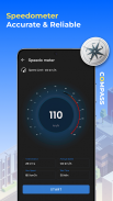
The app is equipped with a compass feature that aids users in finding directions accurately. This functionality is especially useful when users need to orient themselves in relation to their surroundings. The compass feature complements the GPS navigation tools, ensuring that users can navigate effectively even in challenging situations.
GPS Satellite Earth Map View also provides users with the option to save their favorite locations. This feature allows for quick access to frequently visited places, making it easier to plan future trips. Users can create a personalized list of important locations, enhancing the overall convenience of the app.
For those who require offline access, the app offers offline map functionality. Users can download specific areas for navigation without needing an internet connection. This is particularly useful for individuals traveling to remote locations or areas with limited connectivity. Offline maps ensure that users can still navigate effectively, regardless of their internet access.
The application promotes efficient route planning by allowing users to view multiple routes to their destination. This feature enables users to choose the most suitable path based on their preferences, whether they prioritize speed, distance, or scenic views. The flexibility in route selection enhances the overall navigation experience.
GPS Satellite Earth Map View is designed to cater to diverse navigation needs. Whether users are commuting to work, traveling for leisure, or exploring new cities, the app provides essential tools to assist them in their journeys. By offering a combination of real-time traffic updates, voice navigation, and detailed mapping, it serves as a reliable companion for navigating various environments.
The app's integration of live updates and comprehensive geographical information makes it a valuable resource for anyone seeking to enhance their travel experience. With the ability to explore landmarks and obtain real-time traffic alerts, users can navigate with confidence and ease. The combination of features ensures that users can reach their destinations efficiently, making GPS Satellite Earth Map View a practical choice for Android users looking to simplify their navigation needs.
GPS Satellite Earth Map View - APK Information
APK Version: 2.0.18Package: com.gpsview.offlineearth.maps.routenavigation.streetLatest Version of GPS Satellite Earth Map View
Other versions


Apps in the same category


